Azadi channel or Alexander the Macedonian channel!?
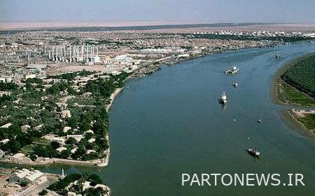
One of the long-standing masterpieces of architecture and engineering in Khuzestan is the waterway that today passes through the middle of Khorramshahr city and is known by at least two names: “Azdi Canal” and “Nhar Hafar”. This man-made artificial waterway, which is believed by Iranian historians to have been built in the 4th century of Hijri during the period of Al Boyeh and the time of the Emirate of Azd al-Dula Dilmi (and for this reason it is called the Azdi stream/canal), according to its digging and excavation, is named ” It is also called “Haffar” and it is functionally similar to the Suez Canal in Egypt, although in terms of dimensions, the size of the Azdi Canal, which is about 4,600 meters long, cannot be compared to the Suez Canal, which is 193.3 kilometers long.
***

The two phrases that have been mentioned are the initial part of the research of Dr. Abbas Imam (Khuzestan Pedagogical University and Professor of Shahid Chamran University of Ahvaz) regarding the Azdi Aqueduct. In addition, he has reached interesting results in this research and has made it available to Isna for publication. Now you read its continuation:
The time frame of the construction of this waterway is not exactly known, but most historians have estimated its construction time between 30 and 50 years. The main purpose of the construction of this structure was to connect the Karun River to Arvand Road (Shat al-Arab) with a much shorter route, and probably reduce the distance between Ahvaz and Basra, because before the construction of the Azadi Aqueduct, vessels had to pass through Bahmanshir and travel a long distance through the peninsula. bypass Abadan and then enter Arvandrud. In fact, it was with the construction of this waterway that today’s general area of Abadan became an island. The point is that before the construction of the Azdi Canal, the Karun River, after flowing from Ahvaz and its downstream villages, joined Bahmanshir about five kilometers before Mohamre/Khorramshahr, and after bypassing the place we know today as Abadan city. It has entered Arvandrud (Shat al-Arab) and finally the Persian Gulf. The historical role of this waterway was, first of all, to greatly accelerate the river trade between Ahvaz-Mohamra-Basra-Persian Gulf, and secondly, it caused the formation and rapid expansion of the city of Mohamra/Khorramshahr on the coast of this waterway at the time of the concession of freedom of navigation to the British Lynch brothers in 1888. ; A development that became doubly important for the development and settlement of Khuzestan with the discovery and extraction of oil in Masjid Suleiman in 1908. Let’s not forget this, during Saddam’s invasion of Iran in 1359 AD, the existence of this waterway prevented the fall of the strategic city of Abadan (and of course the villages and towns related to it).
With this mentality and historical information about the importance of this effective waterway, I was very surprised today when I came across a different article about the construction time and builder of Azdi Canal in one of the historical sources. William Kent Loftus (1385), who resided in Mahmarah/Khorramshahr between 1849 and 1852 (the beginning of Naser al-Din Shah Qajar’s reign), on page 17 of the book “Colonel Loftus’ research travelogue; The first explorer of Susa” points out some points about the name of the founder of Mohamre, the reason for digging this waterway, the existence of an Iranian city called Durin, as well as the establishment of a special garrison in this place in ancient times, points that completely change our historical perception of this structure and related points. he does. According to Loftus:
1. The founder of Mohamre/Khorramshahr was Alexander the Great and therefore named it “Alexandria”.
2. This waterway was dug by order of Alexander the Great to enter the Tigris [منظور شطالعرب/اروند رود میباشد]there is no need to go on the route of Ulyssius (today’s Karun) and enter the Persian Gulf.
3. A ruined Persian city called Durine was probably located near this place.
4. In the same place, Alexander the Great assigns a garrison to his disabled soldiers and names the suburb Pellaeum in honor of his hometown.
5. This city has changed its name several times before the Islamic era.
Because of the historical importance of these points, we quote the entire relevant paragraph from the referenced source below:

Imam Abbas
It is said that the founder of Mahmra was Alexander the Great. Alexander ordered to between 2 rivers Karun and Tigris [منظور شطالعرب/اروندرود میباشد]An artificial waterway should be dug so that, in the form of a shortcut, there is no need for the vessels to leave Ulsius (today’s Caron) behind, then enter the Persian Gulf and then enter the mouth of the Tigris; An aqueduct that can still be seen in the “Hafar” area next to the city of Mahmarah. Apparently, until that date, the Karun was pouring its waters into the Persian Gulf through one or both channels of Khorqban and Khor Bahmanshir (and actually through a promontory, that is, a shallow sea). The place of construction and establishment of Mahmrah is also determined at the junction between 2 Eussius and Tigris rivers and on the sea coast. Alexander built an artificial hill in this place and transferred one of his ruined colonies in the Iranian city of Durine to this place and assigned a barracks to soldiers unable to serve. He named this place “Alexandria” in honor of his own name and the surrounding areas as Pellaeum in honor of his hometown. Of course, this city was later destroyed by the terrible floods of these two rivers, but the Seleucid general Antiochus rebuilt it and named it Antochia in honor of himself. But, this city is also destroyed and for the third time one of the Arab kings named Spasines, the son of Sogdonacus, rebuilt it and built several large dams, docks, anchorages and earthen piers for it, and in honor of the name He calls it “Charax of Spasines” (Laftos, 2005).
Of course, because Loftus compiled his material in the form of a travelogue, he did not mention the details of his historical sources to mention all these details in the text of the travelogue, but we can guess that the historical sources of Loftus must have been either Alexandrian Greek sources or Roman, especially Pliny the Elder’s Natural History.
In any case, to verify this point/points, I referred to the most detailed Persian source related to the performance and era of the Azd al-Dawlah Dilami emirate, entitled “Azd al-Dawlah Empire: How Azd al-Dawlah Dilmi ruled and the study of the situation in Iran during the time of Al Boyeh”, written by Faqihi (1347). , but in that voluminous source (410 pages), nothing was seen except for a general sentence on page 152 as follows:
Moghadisi says about this that Azd al-Dula made a huge river from the Karun river to the Tigris river (meaning Shat al-Arab) four miles long so that travelers could easily cross the desert between the two rivers.

The second referenced source is written by Ruiger (2008) with the title “Political, cultural, religious and civil activities of Azd-Dulah Deilmi: 328-373 AH”. This source, based on relevant Persian sources, has included relatively more information about the Azdi channel. By the way, according to Makdisi in “Ahsan al-Taqasim fi Ma’rifa al-Aqalim” the reason for digging “Fam Azdi”, “Trea Azdi”, “Joi Azdi”, “Hafar”, “New Creek” or “New Creek” [همگی، در اشاره به همان سازه] He considered the reason for the construction of this waterway to be “a problem that stood in the way of shipping routes” because ships had to travel the dangerous route of the Persian Gulf to reach Karun from Tigris and Euphrates and enter the mouth of Karun from there. Therefore, Azd al-Dulah ordered to build a canal between Shatt al-Arab and Karun, which will save the ships from danger to a great extent and also reduce the distance” (p. 126). Ruiger (2008) also cites Lestrange in “Historical Geography of Eastern Caliphate Lands” and adds “Khorramshahr/Mahmareh port is located next to Azdi Creek in the former place of Bayan Creek” (p. 126). The same source, relying on the book “Five Hundred Years History of Khuzestan” by Kasravi, adds, “In the first centuries of Islam, Bayan was considered one of the cities of Khuzestan and had an important trade due to the movement of ships. One of the historical works of Azd-Doleh Dilami is that he widened and deepened the stream, which did not have the capacity for the passage of large ships, and named it after Azdi Stream. It is clear that this work increased the expression” (ibid.). The last important point that Royger raises by quoting from the book “Geographical History of Khuzestan” is by Seyyed Mohammad Ali Imam Shushtri and he is from an author named Mr. Rahimzadeh Safavi in the introduction to the book “The Story of Shahr Bano” (Imam Shushtar, p. 39), Safavi, Hafar In Tareh attributed it to the Sassanians and said that “Tereh was ruined, it was not navigable… [کرده] And with expenses [هزینه] A lot, expanded” but it is a matter of concern that it does not provide the source of the narration, although its authenticity is not far from reliable (Imam Shushtri, p. 39). Anyway, the important thing that can be obtained from the explanations of these sources is that many Iranian/Islamic historians have also believed that the founder of this aqueduct was not Azd al-Dawlah but the rulers of the Sasanian era.
Once, when we put the “general and scattered indications” of Muslim/Iranian historians against the “detailed and almost comprehensive explanations” of William Kent Loftus about the background of the formation of the city of Alexandria/Antiochia/Karkh Spasin/Muhamra/Khorramshahr, the acceptance of the claim of the foundation of this historical waterway by Azd al-Dula Dilmi seems unconvincing and inclines us to vote for the correctness of Laftus’s view that both the city and the aqueduct were founded by Alexander the Great. In any case, it is hoped that the esteemed experts will introduce more detailed sources, documents and documents in the mentioned field if they are available. Also, I hope that the General Administration of Cultural Heritage of Khuzestan (and other related national institutions) will take the necessary measures for the national registration of this provincial masterpiece, although they have promised for years to implement this demand as soon as possible, but so far they have not been successful.
