Getting to know the main faults of Iran
According to Moj News Agency, due to Iran’s geographical location on many faults, this land is constantly under the threat of earthquakes. Earthquake There have been many big and small accidents, which have sometimes caused a lot of financial and human losses.
This issue has become especially important in the last hundred years, when the amount of damage has increased due to the growth of the population and the expansion of various constructions. Therefore, people expect research centers to provide solutions to predict the occurrence of earthquakes in parallel with the progress of science, but not only in Iran, but anywhere in the world, there is still no such possibility. Therefore, currently, prevention of earthquake damage is the best solution. For this purpose, knowing the land and location fault can be considered very critical during construction.
Accordingly, in recent decades, people’s familiarity with the fault and the most important The faults of Iran It has become important. In this regard, this article first introduces the most important faults in Iran with a precise definition of the fault.

What is a fault?
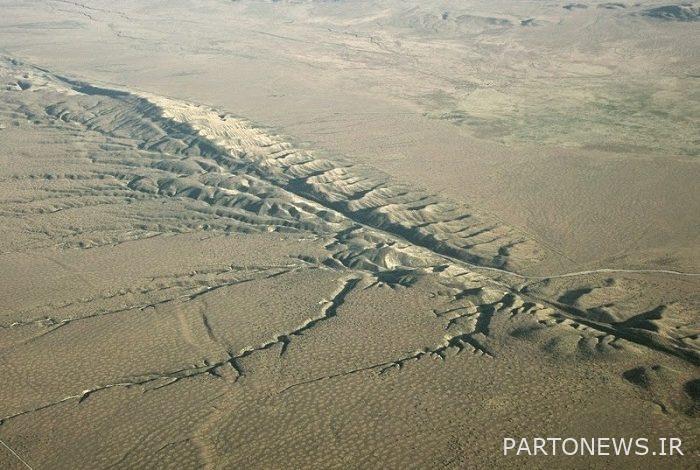
A fault is a break in the rocks that make up the earth’s crust, and the rocks move parallel to it from all sides and move away from each other.
Every crack in the ground is not a fault. What represents one The fault is the rock movement on both sides of it. When the rock movement is sudden, the released energy causes an earthquake. Some errors are very small. But there are also faults that are part of large fault systems, parallel to which rocks slide hundreds of kilometers away from each other.
These boundary line fault systems are huge plates that make up the earth’s crust. For example, in the “Bay San” region of Francisco, active Quaternary faults are part of the boundary between the North American and Pacific plates.
Some faults can also be recognized from space.
What is an active fault?
The existence of a fault in an area shows that there have been changes in its length in the past. These movements are either slow, which did not cause any tremors in the ground, but sometimes it happened suddenly, which is often the same movement. Sudden earthquakes cause earthquakes. Most of the faults are inactive and are actually left over from past deformations.
Errors with names Active faults And we know inactive.
Active faults are said to be faults that, in a certain period, have caused the earth’s layers to be cut off and fractures have been created, and earthquakes have occurred on it, which sometimes people do not feel, and sometimes parts From these faults, they become locked and begin to accumulate energy (this energy is the permanent movement on the surface of the earth, which for Iran is the approach of the Arabian plate to us), so it can be said that the permanent pressure We have seen that this pressure starts to resist and the areas where there are faults are considered as weak points.
We can say that the faults are the plates on which a fracture was created before, which occurred in the process of rotation and completion of the earth.
The faults of Iran
The land of Iran is covered by main and minor faults with different trends. A number of main faults in the geology and structural region of Iran, sedimentary basins, formation of vein deposits and Earthquake-prone areas of Iran They play a role:
-
Faults with an approximate east-west trend
Alborz fault (A)
From the east of Gorgan to Lahijan, it is located between the unit of Gorgan to Rasht and Alborz, and its trend follows the trend of central Alborz. This fault has been active since the Silurian or earlier, and there are no Eocene rocks in its north, but the Miocene marine facies in its north are different from Alborz.
Abik fault – Firouzkoh (AF)
It stretches from Abiq Qazvin to Firouzkoh in the southern part of Alborz, and a part of it is called Mesha-Fashm. Abik fault – Firouzkoh It has been active since at least the Lias period. Because the sediments forming Shamshak (Lias), Mesozoic volcanic activities are more in its north.
Semnan fault (S)
It is located in the north of Semnan and separates the Alborz mountains from central Iran. This fault is located at a distance of 15 to 25 km from the Attari fault, which probably both join each other in the Ahavan-Ghoshe plain. Semnan fault It extends from the east to Damghan and from the west to the De Namak-Garmsar plains. This fault is left rounded and its slope towards the south has created discontinuities in the Eocene rocks of North Semnan.
-
Western Alborz and Azerbaijan faults
Tabriz fault (T)
This fault continues from north of Tabriz after passing Khoi and Mako towards Astara mountains in Turkey. Considering that a trend change is observed along the fault, it is possible that this fault could be the result of the joining of several faults, but in any case, its general trend is northwest-southeast, and it is possible along the Qom-Zafra fault. This fault reaches Zanjan-Soltanieh mountains from the southeast and is dextral. The Tabriz fault in the distance between Khoi and Mako marks the border of the colorful Afra rocks of West Azerbaijan.
Astara fault (A)
This fault is cut with a north-south trend in the east of Azerbaijan and the western part of the Caspian lake from the north of Iran to the Caucasus. Astara fault It has played a role in the depression of the Caspian lake in relation to the land of East Azerbaijan.
Urmia fault (R)
It passes from Mako to the south, from the west of Lake Urmia and ends at Zarineh River. This error continues Tabriz fault It is considered and probably the depression of Lake Urmia is the result of its performance. Due to the absence of Triassic and Jurassic rocks and in contrast to the large expansion of the old shield of Precambrian to Permian rocks in its west, it can indicate the existence of Katangai orogeny. In addition, the activity of this fault can also be observed in the previous Cimmerian phase.
-
Faults of central Iran
Treud fault (Tr)
This fault is one of the faults in the north of the salt desert of Central Iran, which is located in the north of the Derone fault (the big desert fault) with a northeast-southwest trend. Its activity can probably be related to the Caledonian orogeny process, but its leftward movement is certain in the previous Cimmerian.
Miami Fault (My)
This fault passes Shahroud in the north of the Great Salt Desert and probably reaches Darune fault from the east and Attari fault from the west. The northern border of mixed colored rocks is in the Abbasabad-Miami region and separates the two units of Central Iran and Binaloud.
Internal Fault (Great Desert Fault) (D)
This fault extends for 700 km from the north of Nayin to the east to the border of Afghanistan and limits the great desert of central Iran in the northern part. Its latest movement has been rightward and marks the southern border of the Kashmir-Daruna region, where colored admixtures spread. Process fault The interior is inclined to the north from the north of Nain to the east of Qadri, and then it becomes an arc, and finally it stretches to the east-southeast until the border of Afghanistan. Its name is taken from the internal part located in the south of Kashmir.
Qom – Zafra fault (QZ)
This fault continues from Qom to Zafareh (northeast of Isfahan) and is a type of right-striking fault that played a major role in the emergence and formation of igneous rocks of the Eocene period. As mentioned, the Qom-Zofra fault is probably the sequence of the Tabriz fault.
Dehshir-Baft fault (Db) (Nain-Baft fault)
It is stretched from Nayin and Dehshir of Yazd to Kerman region with the northwest-southeast trend. Its western and southwestern limits are marked by the depressions of Gavkhoni, Abarkouh and Sirjan. Along this fault, outcrops of colored mixture can be observed, especially in Nain areas.
Back of Almond fault (P)
This fault passes in an arc from the areas behind Badam and inclines towards the southeast. Fault activity Pushtbadam is related to the Katanga phase and in the Mesozoic, it was effective in creating extraterrestrial and subterrestrial structures with renewed activity. This fault is parallel to other faults such as the Chapdoni fault and limits the eastern border of the Salt Desert.
Kalmard Fault (Km)
The strength of this fault is located in the east of central Iran and in the western part of the old Kalmard shield. This fault reaches the Upper Precambrian, but it was also activated in the Caledonian phase, and its trend, which was initially north-south, then tilted towards the east. Kolmerd fault is of dextral type and caused facies changes in Mesozoic.
-
Faults in the east and southeast of Iran
Harirud fault (H)
This fault is with the north-south direction of Harirud River (Iran-Afghanistan border) and passes the Tejen River and has performed well in the regions of Turkmenistan and the Ural Mountains of the Soviet Union. Its movement is left-handed, and Jurassic and Cretaceous rocks have been displaced on its sides. This fault limits the western part of the Helmand block and passes through the west of the Zabul plain and reaches Zahedan. The length of the part of Hariroud fault that can be recognized in Iran is 825 km. This fault was activated in the Katangai phase and its activity continued in the later phases as well.
Nehbandan fault (Nb)
It is a fault with a north-south trend that limits the eastern limit of the Lot block. Its length is about 750 km and it is inclined towards the east in the southern part and finally it continues towards the Iran-Pakistan border, which Nabavi believes to be the combination of three separate faults. The first movement of the Nahbandan fault is attributed to the Precambrian, which continued in other phases. The rocks on both sides are the upper Cretaceous of Eocene, but around Ten Salam, Paleozoic metamorphic rocks have been displaced.
Nonband fault (N)
This fault also has a north-south trend and its length is 600 km from Beshroieh to Bam area. This fault limits the western limit of the Lut block and especially played an important role in the formation of the Tabas sedimentary basin and the creation of the Jupiter Mountains. The Naiband fault has displaced the oldest outcrops in the area, which belong to the Devonian period, so it is possible that its age reaches before the Devonian and even Precambrian.
Beshagard fault (B)
Beshagard fault in the Beshagard mountains south of Jazmurian passes Qasr Qand and continues with an east-west trend towards the Iran-Pakistan border. Along this fault and smaller faults in the area, outcrops of colored mixture can be observed. This fault is probably the continuation of the Zagros fault, which Minab fault has separated and displaced from the Zagros fault with its north-south trend.
-
Zagros faults
Zagros fault (Z)
It is a fault in the north-eastern part of Zagros with a northwest-southeast trend and a vertical steep slope, and it has acted as a reverse fault. This fault continues especially in the areas of Lorestan to Marivan, and after entering Iraq, it has turned back towards Iran and reaches Sardasht (Nabawi 1355). The sequence of this fault passes along the south-west of Fars. So that its total length is about 1350 km.
In the Fars region, the Zagros fault has a lower slope and is often observed as a landslide. Its movement is dextral and has placed the pre-Cambrian evaporite sediments, which should have been formed in the Qatar-Kazeron evaporite basin, 200 to 300 km away (in Zardkoh). Aminolite and Zagros radiolarite mixtures are located in Kermanshah and Niriz areas of Fars along this thrust fault. The time of the initial movement of the Zagros fault is attributed to the Precambrian, and its movement continued in later periods.
Kazeron fault (Kz)
The length of this fault is about 500 km and it has an approximate north-south trend and is a type of right-handed faults. This fault has caused the displacement of the Zagros region and the Arabian platform. Therefore, it defines the border of the Arabian platform with Iran’s Zagros. The time of its movement is attributed to the Precambrian, but in quartz, its movement started again and the Qar-Kazron earthquakes represent its current age movement.
Minab fault (M)
The previous name of this fault was prison and it was known as right-handed, but its recent movements and the movements of the sediments of the Swedish coastal alluvial defenses are left-handed movements of this fault. This fault is interrupted in the northern part by the Zagros fault, but its continuation can be seen on the other sides of the Beshagard and Zagros faults.
It seems that the Minab fault is a continuation of the Nayband fault and its movement can be similar to the Nayband fault. The trend of this fault is north-south and enters Oman from the south. This fault is important from the point of view that it is located in the direction and important tectonic trend of Ural-Oman and Madagascar.