Qeshm Geopark is a global sustainable model relying on the participation of the local community
According to UNESCO’s definition, a geopark is an area with a sufficient area whose boundaries are clearly defined and several significant geological phenomena are located within its limits, and this area should be able to play an effective role in the economic development of its surrounding communities.
In addition to geological phenomena, Geopark may also have historical, ecological, archeological and other cultural and natural heritage.
Qeshm Global Geopark with an area of 2,600 square kilometers includes the islands of Qeshm and Hengam and 500 meters of the sea border of these islands and Derestan Bay.

This geopark offers a huge variety of geological landscapes along with the variety of different sites, and in addition, it has a special ecological, archeological and cultural diversity.
Qeshm Geopark has 28 diverse and main sites such as Chahkouh Gorge, Star Valley and Tandisah Valley, and its proximity to the mangrove forests located in the north of Qeshm Island, which has five titles, international wetland, biosphere reserve, protected area, special marine area and It is special for birds, it adds to the values and natural attractions of Qeshm Geopark.
Qeshm Geopark is more important due to its location in the strategic area of the Persian Gulf, and on the other hand, this geopark has found a special place in the region and among geoparks due to its location between the geoparks of East Asia and Europe.
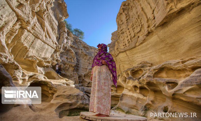
The presence of significant geological phenomena including the salt dome, sulfur springs, salt cave, amazing valley, pristine and beautiful beaches and wildlife in the western part of Qeshm Island and marine mangrove forests, Chahkouh Strait, Aali Strait, Bam Qeshm, Valley of Statues , Kalat Kshataran, Naz islands and dozens of boulders and rocks with beautiful shapes made Qeshm’s name to be registered in the list of world geoparks.
Natural phenomena such as the Valley of the Stars, Korkora Mountain, Chah Kavir, Chahkoh Strait, Karion, Gori Wall, Basira, Jeoling, Shore Valley, Jazirto, Turtle Rock and the sides of the southern coast, each of which has its own beauty. Among these geological attractions are considered.
Mangrove forests along with unique biodiversity, Dolphin Bay, Balashahr, coral beaches and mudflats are other natural landscapes that have doubled the value of Qeshm Geopark.
In addition to these attractions, the Geopark museum, the barge-making workshop, the British cemetery, and the historical port of Laft are other valuable assets of the Qeshm Geopark, but this alone is not enough, and what gives a geopark its identity is participation and active presence. The local community is involved in the promotion, development, conservation and management programs of the Geopark.
The local community with its own indigenous beliefs, rituals, customs, lifestyle, art and knowledge is the real capital of a geopark.
All these natural and spiritual features are tied together in Qeshm Geopark, so the best and most appropriate way to preserve this valuable miracle is the participation of the local community.
Participation of the local community in the development of Qeshm Geopark
Qeshm Geopark, with its natural and biological attractions, geological attractions, common geological-biological attractions and historical-cultural attractions, which is the least place in the world to find this valuable collection in one place, in 2005 as The only geopark in the Middle East was recognized in the global network of geoparks.
From the point of view of the experts of the global network of geoparks, the geopark is a management in interaction with the local community that achieves sustainable development by institutionalizing this policy, a development in which the people of the villages adjacent to the geosite benefit, and these people themselves are the best model for the program. are considered geopark protections.
However, due to the lack of people-oriented activities and their lack of participation in the sustainable management of Qeshm Geopark, not much success has been observed and achieved in this field.
With unique natural phenomena, Qeshm Island has long been considered one of the most important tourism hubs in the south of the country, and every year we see a significant presence of tourists on this island. entered into natural resources, which will lead to the gradual destruction of nature.
It is obvious and clear that if this trend continues and the lack of participation of the local people in the activities related to the Geopark, the value of the geological heritage and other natural values of the island will decrease day by day and the future generation will not benefit from it.
Optimal planning and management of Qeshm Geopark can provide livelihood assistance to the people of the island, even in remote areas, and attract their participation in the management of the Geopark.
Creating sustainable livelihoods through ecotourism (nature tourism) and geotourism (land tourism) will lead to economic development and improvement of the quality of life for the people of the villages in the territory of Qeshm Geopark. Cultural values are created among the local community and their sense of responsibility is strengthened.
The beautiful island of Qeshm overlooks the Strait of Hormuz and the inlet to the Persian Gulf and the Sea of Oman.
This island, which is the largest island in the Persian Gulf, is one of the most strategic islands of Iran and the Persian Gulf due to its proximity to the Indian Ocean, the presence of oil and gas resources, petrochemical and refinery units and offshore equipment, and having port facilities for large ships (in the Panamax category). It is world famous because of its fueling services for ships passing through the international waterway and its energy and bio-technology parks.
On the other hand, the natural and historical features of this island have made Qeshm one of the main tourist destinations in Iran and the Persian Gulf region.
Qeshm commercial-industrial free zone covers about 300 square kilometers of this island. Due to its location in a key point of the North-South transit corridor, access to the East-West international flight corridor and its port facilities, which are complementary to the Shahid Rajaei port, this area plays a prominent role in global trade and commerce.
The main goals and axes of the activities of this commercial-industrial free zone include the development and expansion of the transit and transportation industry, the expansion of trade and commercial services, energy-intensive industries, biotechnological industries and marine resources, tourism industries, fisheries and industrial fishing, oil support services and parks. is energy