The precipitation system will enter the country tomorrow
According to Moj News Agency, based on the analysis of synoptic and futuristic maps of the Meteorological Organization, a calm and stable atmosphere prevails in most parts of the country today, and in industrial and densely populated cities of Tehran, Arak, Karaj and Isfahan, air quality decreases with increasing concentrations of air pollutants.
From Wednesday afternoon, with the arrival of the precipitation system in the west of the country in areas of the western strip and southern slopes of Alborz in Qazvin, Alborz and Tehran provinces, snowfall, rain and temporary strong winds are forecast.
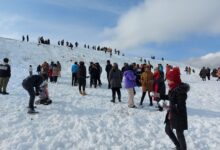
Thursday With the expansion of the rainfall system in areas of northern Fars, Bushehr, west of Isfahan and areas of northeast and east, snow and rain will occur. Also, with the northward currents on the Caspian Sea in the northern coasts, it rains and snows in the highlands.
Rainfall intensity will be snow for Chaharmahal and Bakhtiari, east of Lorestan, northeastern Khuzestan and south of West Azerbaijan.
According to the Meteorological Organization, precipitation continues on the shores of the Caspian Sea, North Khorasan and North Khorasan Razavi on Friday, with winds and a relative decrease in temperature forecast in the southeast and east.
In the northern half of the country, wind and a decrease of 4 to 6 degrees of temperature are forecast and the system will gradually leave the country.
System Description: Precipitation of precipitation system
Start time: Wednesday afternoon 11/6/1400
End time: Friday 1400/11/08
Type of hazard: rain and snow, temporary strong winds, lightning and fog
Area of effect:
Wednesday 11/06/1400: Chaharmahal and Bakhtiari, South West Azerbaijan, Kurdistan, North Kermanshah, Zanjan, Heights in Qazvin, Alborz, Tehran Provinces.
Thursday 11/07/1400: Gilan, Mazandaran, Golestan, Tehran, Alborz, Qom, North Khorasan, Eastern half of Khuzestan, West Azerbaijan, East Azerbaijan, Ardabil, Hamedan, Markazi, Zanjan, Kermanshah, Lorestan, Kurdistan, North Fars, West Isfahan, Semnan Heights.
Friday 11/8/1400: South West Azerbaijan, West Kurdistan, Mazandaran, Golestan, North Khorasan, North Khorasan Razavi.
Danger effect: reduced visibility, slippery roads, possibility of blocking rural roads due to snow, possibility of cancellation or delay in flights, snow blizzard, flooding of urban thoroughfares.
Recommendation: Avoid stopping and moving along rivers and canals, reopening slopes and escalators, avoiding unnecessary trips, collecting cattle from rivers and canals, avoiding mountaineering activities, equipping vehicles with winter equipment, and preparing executive equipment.
System description: Infiltration of precipitation system with snowfall
Start time: Thursday morning 1400/11/07
End time: Friday 1400/11/08
Danger type: snowfall
Area of effect:
Thursday 11/07/1400: Kohgiluyeh and Boyerahmad, Chaharmahal and Bakhtiari, Eastern strip of Khuzestan, West Kurdistan, Southwest of West Azerbaijan, Heights in Tehran, Alborz, Mazandaran, Qazvin.
Friday 11/8/1400: Heights in Mazandaran and Golestan provinces.
Risk Effects: Blizzard, frost, blizzard, avalanche, slippery, fog and reduced visibility on roads, blockage of roads and snow removal, the possibility of gas pressure drop, flight delay or cancellation.
Recommendation: Avoid mountaineering activities, avoid unnecessary trips, equip vehicles with winter equipment and ensure sufficient fuel, manage energy consumption and prepare governorates and other relief devices to deal with possible damage, prepare for snow removal.
.