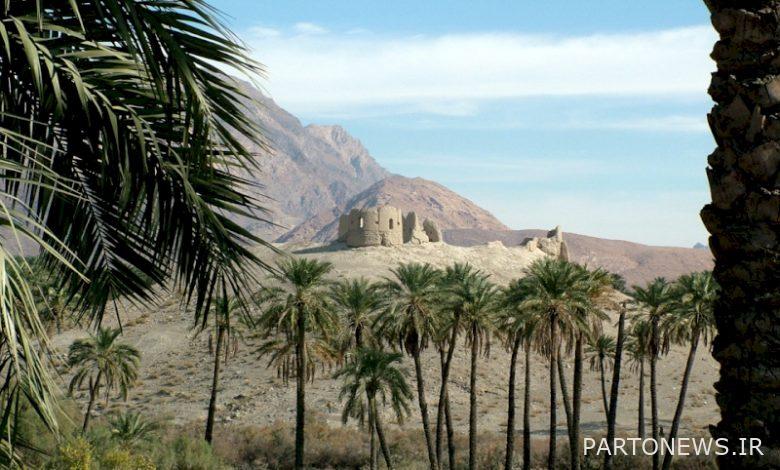
Hajiabad Castle, a monument to the history of warfare
History of the work and the process of its formation
Hassan Abbaspour Daragahi writes about the castle in the book Green City: A Look at the Geography and History of Hajiabad:
“From the people of Hajiabad, do you know the time of this fort until the age of thirty?” They answer only God knows. It is said that this water well inside the castle, which was dug in the heart of Khara, was once full of water and even its water was problematic because of Zamzam. “In any case, these myths or legends are not without reason. Even if there is superstition, superstition can be complete and valuable if there is no shop and shopkeeping in it.”

The ancient castle was built on a rock, southwest of the city of Hajiabad.
In the northwest of the castle, which was the ruling house, there was a well in the heart with mortar and hedge. It is interesting that the well was built by Zoroastrians. In this part, other wells also poured water to the castle dwellers.
A private bath belonging to the ruler was erected northeast of the castle. But a public bath was built east of Pir Ghayb and outside the castle wall. The foundations of the castle were laid on mortar and the walls were made of raw clay, which left its time worn out to the point that nothing is left of it today.
The castle is surrounded by a water ditch to make the castle inaccessible when the enemy attacks by destroying the stairs.
Three kilometers west of Hajiabad Castle is Chaldean Castle. The castle is built on a hill. “There were only a few watchtowers in Chaldean,” said locals. Although this hypothesis is plausible, it can be accepted that the towers that guarded and guarded the main castle were themselves built inside smaller castles. Continuing the defensive aspect of the fort, in the neighborhoods of Bustanoviyeh and Vedravazo, and probably in the neighborhood of Good Kahnoyeh, which are also around the fort, there are embankments that may have stood as a refuge or stronghold as a front line against the enemy. Apparently, the castle, which was built in the days of pre-Islamic governments, was rebuilt by the kings of Hormuz. Due to the importance of the castle in creating security in the region, political forces tried to take control of the castle.
Everyone who ruled over Hajiabad Castle had the villages of Ahmadi, Tarom, Farghan, Dargah and even Rudan.
It is said that Hajiabad fort, due to its situation, was destroyed by Timur Lang’s troops and set on fire after the massacre of the inhabitants. Later, this fort was rebuilt by the kings of Hormoz and was renamed Safin Fortress, and then the central government came under the auspices of the Kingdom of Hormoz and the local ruler Ahmadi, Rudan, Rudkhaneh, Farghan, Tarom, Farg, Dargah and Abshour followed the ruler of Hajiabad.
The ruler of Hajiabad was a tributary and subject to the kingdom of Hormuz. After the extinction of the kingdom of Hormuz, the date of which is unknown, and the coming to power of the Iranian government and the overthrow of the sectarian monarchy, Habibaullah Khan Ghavam, the governor of Persia, covered the coastal areas from Bushehr to the border of Sistan and Baluchestan.
The people of Hajiabad, whose militant spirit prevented them from accepting the servitude of the governor of Persia, named an army under the personal command of Sheikh Nawaygan with three cannons, equipment and weapons necessary to capture Hajiabad fortress and suppress the people and force them to obey Hajilabad And they settled in the famous place of the garden ridge below (the hills south of the castle) and the besieged people were forced to settle in the castle. Takht-e Pol, a place of transportation, was removed from a ditch full of water, which was flooded by two aqueducts, and the necessary precautions had already been taken, and the attacking forces, using their artillery, set fire to the watchtower and houses, but People regularly rebuilt the destroyed neighborhoods at night. The siege lasted for 6 months until the castle’s inhabitants ran out of food and were forced to feed on date kernels, plant seeds and tree leaves. They succeeded in defeating the enemy in the third ambush, and a large number of enemy forces were killed and wounded, and they were forced to retreat to Persia, and the six-month siege was broken, and the fort and its inhabitants were liberated.
The last restoration of the castle was done by Khans Larestani Nasir Khan and Ali Khan. After that, due to the domination of the central government, such forts no longer had a role in guiding and protecting local powers. Not only Hajiabad fort survived, but also regional forts such as Kafran fort in Gahkam, Tarom fort, Bainuj fort, Tashkuyeh fort and Bakan fort were also destroyed.
Three kilometers from Hajiabad Castle, there is Kaldan Castle, which is actually a tower built on the hills, and another tower is located in the eastern part of Hajiabad, where the current water source is located. The two towers were built to protect the main fortress of the city, and in Bustanovieh and Darvazo, there are places called trenches, which were both a refuge and a front line in the wars.
Khans and sheriffs who ruled over Hajiabad fort in the last century are: Ali Khan and Nasir Khan Lari, after them Hussein Khan Bahador Mirza who came from Sultanabad and conquered the fort. After him, Agha Mohammad Ali Khan, who was killed by the Arabs. Ali Reza Khan (Solat Sultan), Haji Khan Daragahi, General Mohammad Reza Kiwani, Representative of President Abdul Karim.
During the Khan Khali period, domination of Hajiabad Castle was the cause of bloody battles that resulted in nothing but the destruction of the castle and the blackmail of the poor villagers. The bloody and treacherous conflicts between Nasir Khan and Ali Khan, and later between Haji Khan Daragahi and Ali Reza Khan, are among the sectarian divisions that prevented the growth of Iranian feudalism.
When Haji Khan captured the fortress, Reza Khan complained to Ghavam Shirazi, the governor of Persia. Ghavam informed Haji Khan of the order to evacuate the castle. From then on, Alireza Khan ruled the castle until the end with the title of Solat al-Sultan, which was given to him by Ghavam.
Introducing the castle
The castle is built on a relatively low hill, but dominates the city of Hajiabad and on the banks of the seasonal rivers that surround it. The shape of a polygonal castle is irregular, which in general can be compared to a parallelogram. In fact, the shape of the castle plan is due to the efforts of its architects to maintain the horizontal alignment by following the topography of the natural bed of the castle.
The area of the castle is about 3075 square meters and its longest ramparts (on the southern front) are 65 meters and the shortest ramparts (on the eastern front) are 32 meters long. It should be noted that nothing is known about the fortifications of the castle, except for a few, mostly at the junction of the towers.
Today, the Journal of Castle Architectural Structures has three circular towers, a rectangular tower (probably the entrance to the castle), and a rectangular royal mansion (hereinafter referred to as the pavilion). This building on the south side of the castle is so close to the southern rampart wall that its wall on this front seems to have been part of the rampart wall, which has not been proven in more detailed studies.
Some of the old people of the city talked about the existence of a moat that once existed around the castle, but in the field studies and the study of the topographic map, no evidence was found to prove this claim.
Examination of the aerial photograph of the castle in 1345 shows that the fortification between towers number one and two and also the eastern half of the southern fortification (between tower number two and the pavilion) consisted of two parallel walls and among the castle walls, only parts of these fortifications remain.
The architectural structure of the castle
Clay and clay strata are the main materials used in the construction of castle buildings, and therefore the castle can be considered a brick structure, but the substructure and porcelain of these structures have been made using carcass stone with hemispherical gypsum mortar. In the towers, on top of the stone chair, clay layers have been used to base the walls, and in the level close to the inner floor of the towers, where the architectural spaces are formed, bricks with dimensions of 21 x 21 cm have been used.
The remaining sections of the ramparts show that most of the walls were about 85 cm in diameter (about the size of 4 bricks).
Tower number one is protected by a large brick backing against drift from the steep slope of the hill. The plan of this tower was circular in shape, and now its western part has been damaged. The tower has a large and relatively high stone foundation that has suffered local damage in the southern part.
Tower number two relies on two supports, which are structurally different from the support on tower number one. This means that the back of Tower No. 1 has a brick body, while the back of Tower No. 2 is made of carcass stone with hemispherical gypsum mortar. Also, these supports were tall in relation to the height of the tower and were able to protect the upper surfaces of the tower well at the points of contact.
Tower number three is the only tower that has traces of opening. This tower has suffered a lot of damage compared to towers 1 and 2, and it seems that the lack of support in it has been very effective. This tower is also built on a bed of stone stratification, but its stone bed is not as wide as towers number one and two.
Tower number four is very different from other towers in terms of appearance. The rectangular shape and numerous openings in its structure distinguish this tower from other towers (which have a circular design). This tower (if it can be properly called a tower) seems to have had a different function from other towers.
Field surveys revealed that the route most commonly used to climb the hill today is from the east side, somewhere near Tower One. Currently, this route is the gentlest slope to climb the castle, and even locals can easily climb the hill about 22 meters from this part by motorcycle.
The inside of the castle with dimensions of about 11.50 meters by 13.50 meters appears in a rectangular shape. The plan of the pavilion has three characteristic parts: in its central part, there are three equal and rectangular spaces connected to each other. On both sides of this section and in the direction perpendicular to it, two other large rectangular rooms have been formed, and the entrance of the building is also located in the north room. The shape of the plan and the features on the walls leave almost no doubt that the covering used in the pavilion rooms was a kind of arch.
Castle use
In historical texts, there is no trace of a city called Hajiabad in this area. In fact, the transformation of Hajiabad from a village to a city and its centralization, owed to the Sis Railway in the first Pahlavi period and subsequently, the location of Hajiabad on the edge of the most important transportation route from north to south has been. Of course, this does not mean that Hajiabad has been far from such routes in the past, but it is an emphasis on the reason for its significant development in recent decades.
On the one hand, the fortifications of the castle are not strong enough for its inhabitants to withstand a massive invasion, and on the other hand, elements such as large water storage and food storage spaces are not visible in the castle. Therefore, it is very unlikely that the use of the castle in the role of a defensive fortress is defined. Due to the limited defensive potentials of the castle and the existence of numerous caravanserais along the caravan routes on this area, the possibility of using the castle as the headquarters of the monks is not far from the mind. Castles with similar coordinates can be found in different parts of the country.
Existence of main roads that reached Sirjan and Pars, Khuzestan and Mesopotamia and was the largest connecting axis of southwestern Iran with Indus Valley and India and beyond. .
References:
– Chubak, Hamideh, Jazmourian Cultural Sequence – The Old City of Jiroft in the Islamic Period, Thesis Page 196
– Eghtedari, Ahmad, Remains of ancient cities on the coasts and islands of the Persian Gulf and the Sea of Oman
– Fakhar, Zarrin, fortifications and fortresses in Sassanid Iran
– Narration, Marjan: Hajiabad Castle Survey Report, General Directorate of Cultural Heritage, Tourism and Handicrafts of Hormozgan
Green City: A Look at the Geography and History of Hajiabad, Hormozgan, by Hassan Abbaspour Daragahi, Afsar Publications, 2006
* Report: Maryam Nabipour Gisi
.