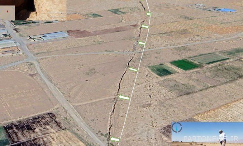
Seeing the 300-meter subsidence gap in the Neishabur Plain! + Photo

In an interview with Moj news agency, it was mentioned;
A faculty member of the Road and Urban Research Center said: “During my visit to the Neishabur plain, we saw a gap that was more than ten meters deep, more than one meter wide, and more than three hundred meters long.”
According to the social reporter of Moj News Agency, “Danger Land subsidence “In our country, it involves more provinces and cities day by day, and it is feared that sooner or later the effects of this phenomenon, which is known as Earthquake It is mentioned in the lower layers of the earth, it appears on the surface of the earth and endangers the lives and property of the people of our country.
Currently, 602 plains out of 609 plains in the country are threatened by subsidence, which is one of the most serious threats to the Neishabur plain. The first signs of land subsidence appeared in the Neyshabur plain in 2005, and now after 17 years, these deep and long sinkholes are clearly visible in the western parts and gradually in the central parts of Neyshabur. Sinkholes that threaten agriculture, animal husbandry, environment, wildlife, railway lines, water, gas, facilities and buildings of this city.
According to the regional water statistics of Razavi Khorasan province, the phenomenon of subsidence in the Neyshabur Plain with an average national settlement of 86 mm per year is almost 20 times the global acceptable final settlement limit.
This subsidence, which is caused by excessive withdrawals from underground water resources, with the discharge of water from the pores of fine-grained sediments due to the weight of the upper layers of the aquifer, the compression of these sediments, and the occurrence of plastic behavior of fine-grained materials in the form of seams and tensile cracks, the depth of which ranges from a few centimeters to a depth of dozens m is localized and usually occurs in the middle parts of the plain.
In this regard, Ali Baitullahi, a member of the academic faculty of the Road and Urban Development Research Center, in an interview with Moj regarding the assessment of the effects of land subsidence in the Neishabur Plain, stated: In my last visit to the Neishabur Plain on the 9th of Mehr, there was a surprising and severe drop in the water level in the area. It was clearly seen in the last few decades and has put the beautiful and unique plain of Neishabur in serious danger.
Read more:
Subsidence, a cancer in the heart of the earth/ the need to address this phenomenon in the 7th development plan
Drought and scarcity of water, a crisis that is still not taken seriously/experts warn; Combating drought, sustainable development and its management
He continued: In an area where the underground water level used to be less than 20 meters, now the depth of these waters has reached 200 to 300 meters, and even in the areas adjacent to a city such as Ghazali, their depth has reached 120 meters. This will greatly affect the urban development of Neishabur.
A faculty member of the Road and Urban Development Research Center said: While investigating this subsidence zone, along the main line of the gas pipeline, I came across the deepest subsidence zone that I had ever seen, and the image we recorded of this phenomenon with the research team is a testimony of the disaster. The irreparable consequences of land subsidence.
Baitullahi noted: The depth of this gap was more than ten meters, its width was more than one meter and its length was more than three hundred meters. I, who have visited many subsidence zones in the country, have never seen such dimensions of subsidence cracks.