The implementation of the Persian Gulf Bridge, Qeshm’s Sustainable Development Circle, towards global trade

Qeshm Island, as the largest island in the Persian Gulf and with a geostrategic position where on average five large commercial ships or oil tankers pass through it every hour, is undoubtedly of special importance for Iran’s economy and foreign trade.
Compared to other free and successful areas in the region, such as the free areas of the UAE, Dubai, Kuwait, Qatar and Bahrain, this island is proportionally closer to open waters between 200 and 300 km, and from the point of view of potential economic capacities, it is able to expand and develop in It has the fields of industry, trade, tourism, transit and re-export.
In addition, the location of Qeshm Island and the Strait of Hormuz is very important from a military and security point of view, both for Iran and other countries in the region dependent on oil revenues, and for the industrial world that consumes oil in the Middle East.


The security of this region is actually a trans-regional and global issue. The presence of a large number of military forces and related bases on the southern shores of the Persian Gulf is a clear proof of this fact.
From a defense point of view, this island plays a critical role in maintaining the security of other islands such as Hormoz, Lark, Hengama and protecting the Strait of Hormuz, protecting the southern coast of the country and Bandar Abbas’ commercial-strategic axis into the Iranian plateau.
Among the other security features of this island, it can be mentioned that it functions as an Aqaba and the center of gravity for the support of Big Tunb, Small Tunb and Abu Musa islands, which in turn facilitates any military maneuvers in the Persian Gulf and the Strait of Hormuz and saves money. It provides the unity of the naval command in the forces, cost and supply.
The separation of this island from the main land is the most important obstacle in the way of operationalizing potential abilities. This problem can be solved through the construction and implementation of the Persian Gulf bridge in the closest distance to the mainland, which brings the development of the North-South corridor.
In addition, the construction of this bridge can bring various other advantages in regional and extra-regional dimensions. In this connection, for example, we can mention the opening of commercial transit lines with neighboring countries and the connection of Asia or Europe from inside Iran.
Iran has approximately 3,900 kilometers of water border on its southern shores in the Persian Gulf and its northern shores in the Caspian Sea. By connecting the ports located in these 2 seas to each other (by road and railway), the important points of the world from East Asia to Northern and Central Europe are connected and in the field of sea transportation, Iran becomes a bridge in the strategic region of the Middle East and countries. The Persian Gulf becomes Establishing this connection will bring billions of dollars to Iran annually through trade, transit and re-export of goods.
Undoubtedly, the construction of the Persian Gulf bridge and its connection with the large port of Kaveh on Qeshm Island and other ports that will be completed or built later on this island will facilitate and enable the process of this huge commercial development in relation to the mainland.
The comprehensive Persian Gulf communication network project with the aim of connecting the mainland to Qeshm Island (the largest island in the Persian Gulf and the Oman Sea with an area of 1,500 square kilometers) has a history of 40 years. This plan has been followed seriously since 2005 and through the necessary hierarchy.
The comprehensive communication network plan of the Persian Gulf, centered on the Persian Gulf bridge, “a plan that, relying on four projects, port, bridge, road and rail, in the first stage, creates a new route from Qeshm in the North-South transit corridor, and in the second stage By accepting the role of a large commercial warehouse in the region, it will assume the centrality of distribution and distribution of goods with the aim of replacing the UAE.”
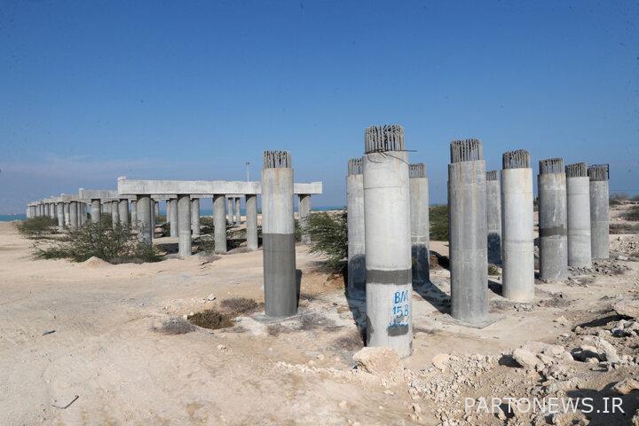
This plan includes the construction of about 92 kilometers of 2-lane highway, 86 kilometers of 2-lane railway, 2,200 meters of bridges, and the development and equipping of Kaveh port in Qeshm Island.
Considering that 300 square kilometers of this island has been defined and announced as a commercial-industrial free zone and the rest of it as a special economic zone, the contribution of this plan in increasing the economic charts of the region and the country, a development plan and economic infrastructure programs of the people’s government is significant. Is.
Beneficiary countries will welcome this new route in the North-South Transit Corridor for 2 reasons: reducing transportation costs by at least 30% and reducing transit time by 40%.
In order to clarify the dimensions, mechanism and various benefits of implementing this plan, it is necessary to review key points in this plan.
In this plan, 2 Kaveh ports in Qeshm and Shahid Rajaei port in Bandar Abbas will have a coordinated and complementary function, so that each of them can help the other in certain circumstances by accepting part of the goods exchange duties in the transit route of the country.
Creating a second route on the south coast of Iran can provide peace of mind for the countries using this vital route and lead to more stability of this route.
The natural capabilities of Kaveh port, the 18-meter high water inlet and no need for dredging, have greatly reduced the maintenance costs of this port compared to Shahid Rajaei port, making it the cheapest coastal port in Iran. In this sense, this new transit route can be a low-cost alternative for the shrinking national economy.
It is expected that after Qeshm Island is established as a new transit route in the North-South Corridor, with this route having relative advantages in the regulations and laws of free zones compared to the mainland, as a center for warehousing and distribution of goods and cargo. To play an effective role for the countries of Central Asia benefiting from the transit route.
Due to the reduction of transportation costs and the transit time of goods from Qeshm, the number and degree of dependence of the countries that have relations with Iran on this route has gradually increased, and the economic and political resources will be a blessing for the implementation of this huge national plan.
The implementation of this plan will increase the demand for the use of vast lands in Qeshm. With the initial investment of the project in the port, road and rail projects, the first wave of economic benefits will be directed to the transportation sector and the goods terminal, and the level of employment in the navigation, fleet and ancillary services sectors will increase rapidly. Business and commercial sectors such as banking, insurance, accommodation and welfare services will also have an acceptable growth.
The decrease in the cost of goods and services in the free zone due to the existence of the rail and road transport network will increase the production of goods and services in the free zone of Qeshm, this advantage will encourage domestic and foreign investors to invest in Qeshm. It will create indirect employment in addition to the direct employment of the project.
Due to the passage of a significant amount of raw materials, production inputs and intermediate goods through Iran, many commercial opportunities are provided for Iranian and foreign manufacturers and traders. By identifying the route of relatively cheap goods in this route, these goods will be used in production or export again. It is expected that a part of transit goods will be deposited in the Qeshm Free Zone in a planned manner and become the source of new products.
Being on the way of goods transit and identifying the needs of the destination countries can increase the ability to export goods for the country and by completing the second part of the project as a warehousing and distribution center, we can enjoy more commercial benefits.
The increase in income in the sector and sub-sectors related to the plan will lead to the per capita income of residents and economic operators in Qeshm. In this way, by increasing the level of economic and social well-being, people will have more facilities, which will reduce poverty in the island.
Reducing the difficulty of traveling to Qeshm Free Zone due to the implementation of the Persian Gulf Bridge Project and the existence of a cheap rail transportation system increases the desire of travelers to travel to Qeshm from the farthest domestic and even foreign places. In this way, the implementation of this project will bring tourism boom in the pristine and spectacular island of Qeshm in terms of history and nature.
The implementation of this plan will also have positive political and military effects, and from the juxtaposition of all these works, it can be seen that Qeshm, as the center of gravity of this plan, is the founder and flag bearer of a new role for Iran in the Persian Gulf region and a great move in the economic It will be national.
Access to markets with a population of more than 350 million people in the surrounding areas of Iran provides the necessary platforms for the expansion of the country’s commercial economy in an effective manner.
In this context, Iran now has commercial-passenger relations with neighboring countries through internal land routes and railway lines, and with the construction and implementation of a railway line approximately 35 kilometers long from the intersection of this bridge with the mainland to Shahid Rajaei port, it will connect Qeshm Island. It is established with the country’s national railway.
The realization of this task also requires the construction of a railway from the Laft section in Qeshm Island to the industrial centers and Bandar Kaveh with a length of approximately 24 km and the construction of a four-lane transit road with four round-trip lanes with a length of 65 km from Bandar Pahl to Bandar Abbas.
By connecting Qeshm Island to the country’s national railway, the connection with the 2-way international port of Kaveh with the strategic and commercial port of Abbas will be completed from a commercial-transit point of view and the possibility of access of Qeshm Island to the distant lands of Iran’s borders will be provided in regional-international dimensions. .
With the implementation of the Persian Gulf bridge and the connection of Qeshm Island to the back shore and the mainland, access routes from the Qeshm Free Zone to important economic centers inside the country, neighboring countries and other countries in the region will be established separately or combined by railway and asphalt road. will be
The cities of Shiraz, Kerman, Zahedan, Mashhad, Isfahan, Qom, Arak, Tehran, Semnan, Sari, Gorgan, Qazvin, Zanjan, Tabriz are directly connected to Qeshm Island through the country’s railway network.
Other centers inside the country, including Rasht, Ardabil, Urmia, Hamedan, Kermanshah, Sanandaj, Shahrekord and several other cities will be connected to Qeshm Island by asphalt road or a combination of railway and road.
With the construction of this bridge, Qeshm Island will have a direct connection with the neighboring countries in the field of goods transit through the railway and with the distant countries through the railway and road lines of these countries.
Through Bandar Abbas, Bafiq, Mashhad and Sarkhs, this island is connected to Turkmenistan and Central Asian countries, and on the way through Uzbekistan and Kazakhstan, it is connected to China’s railway network on one side, and on the other side to the overseas railway route. Siberia and the eastern regions of Russia are connected, which will continue to the port of Vladivostok on the coast of the Sea of Japan and the Great Ocean.
Another route that passes through Tehran, Zanjan and Tabriz is divided into 2 separate routes. One of these 2 branches is connected to the Nakhchivan Autonomous Republic and the Caucasus countries through the Jolfa border, and then it is connected to the Russian railway network and through that to the railways of Eastern Europe, the Baltic Sea and the Scandinavian countries. Other branches of this route continue to Turkey through the Razi border and finally connect to the European railway network to the Atlantic coast.
Considering the geographically closed position and the lack of direct access of Central Asian countries to international open waters, the transit connection through Iran and the Qeshm Free Zone for these countries is considered as a logistics center and support for regional trade and transport economically. It will be absolutely necessary and beneficial.
The countries of Russia, White Russia, Ukraine and some European countries on the one hand and the countries of China, Mongolia, North Korea in East Asia and the countries of Afghanistan, Pakistan, India and Bangladesh bordering Iran or in South Asia in separate and direct transit routes. Kala is located with Qeshm Island and the large port of Kaveh.
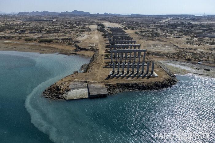
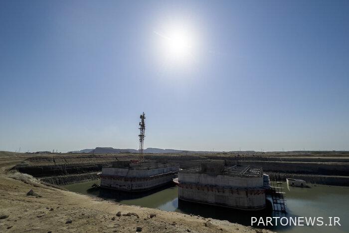
The 3,430-meter-long Persian Gulf bridge includes 360-meter spans and foundations on the sea, a 32-meter deck width, and has four vehicular traffic lanes, a railway traffic lane, and an emergency and pedestrian route. After implementation, it can connect Qeshm Island to the mainland.
To complete one of the four pillars of the Persian Gulf comprehensive communication network plan, including the development of Kaveh port on Qeshm Island, the construction of 92 km of highway from Kaveh port and extension to the national line through the Persian Gulf bridge, the construction of 86 km of railway from Kaveh port and extension to the national line Through the Persian Gulf Bridge, the construction of the Persian Gulf Bridge in order to complete the pillars of the project on the sea requires an investment volume of 400 million euros.
This bridge is located between Qeshm Island and Bandar Abbas, and in addition to the development of the North-South transportation corridor, it will provide the development of Kaveh Wharf and the possibility of building a highway and railway along this route.
With the construction of the Persian Gulf Bridge, the transit of goods from the Qeshm Free Zone becomes economically justified, so that the majority of the goods that were transited through the North-South Corridor are done through this bridge, and the import and export of goods are based on a series of Rules and regulations will be easier.
The Persian Gulf Bridge will connect from the area of Laft Wharf in Qeshm to Pahl Wharf in Khamer city and will connect Qeshm Island to the mainland.
Qeshm Island with an area of 1,500 square kilometers from the Strait of Hormuz, parallel to the south coast of Iran, is 135 kilometers long and 11 kilometers wide, and it has 300 kilometers of coastline.
Qeshm city includes Qeshm, Hengam and Lark islands with about 150,000 people, spread out from the Strait of Hormoz parallel to the coast of Hormozgan province, with a length of 150 km and an average width of 11 km, in the waters of the Persian Gulf.